News
As one passes beyond the place of the midday, the Ethiopian land is that which extends furthest of all inhabited lands towards the sunset. This produces both gold in abundance and huge elephants and trees of all kinds growing wild and ebony, and men who are of all men the tallest, the most beautiful and the most long-lived.
Herodotus,The Histories, Book 3, Chap. 114
Kush, Nubia and the Sudan
According to Herodotus, who wrote these words in the 5th century BC, the mysterious Ethiopia (Aithiopiae), a land of people with sunburnt faces, stretched from the Sahara to India, but its heartland was in the northern and central part of the modern day Sudan. Over the last five millennia of its history the region was known under various names: the ancient Egyptians called it Ta-Sety (Land of the Bow), the land of Wawat , and later the land of Kush. The word “Nubia” appeared only during the Roman period and it might have derived from an Egyptian word nebu, which means gold. Paradoxically, however, we do not know what the indigenous inhabitants called the place in their own language. Today, Nubia in a broader sense has become something of a synonym for northern Sudan. The name “Sudan” itself is only a few centuries old – it was given to this land by the Arabs who referred to the dark skin of the natives.
The land of six cataracts
The main elements of landscape in the middle section of the Nile are the six cataratcts – the largest of rock rapids. The fertile Nile valley is surrounded on both sides by rocky heights forming natural boundaries of the Eastern Desert and the Libyan Desert. The region is divided conventionally into Lower Nubia between the First and Second Cataracts and Upper Nubia to the south of the Second Cataract. This division roughly corresponds to the course of modern day border between Egypt and the Sudan. However, both historical and geographical circumstances have made the two regions an inseparable whole, and to speak of each independently seems absolutely impossible.
The rocky region of Batn-el-Hagar (Belly of Rocks) had always formed a natural barrier against expansion from the north. Dongola Reach between the Third and Fourth cataracts has been densely populated since the antiquity, similarly as the fertile Butana, the region encircled by the course of the Nile and called “an isle” in the ancient times. Here the monotonous desert landscape gives way to sahel – a zone of transition between the Sahara and savannah. Finally, beyond the Sixth Cataract lies Khartoum, where the waters of the White Nile and the Blue Nile meet.
It was geographical location that made the Sudan a corridor and a crossing path for the routes of trade and cultural exchange between the Mediterranean world and Africa, and between the Arabian Peninsula and the Sahara
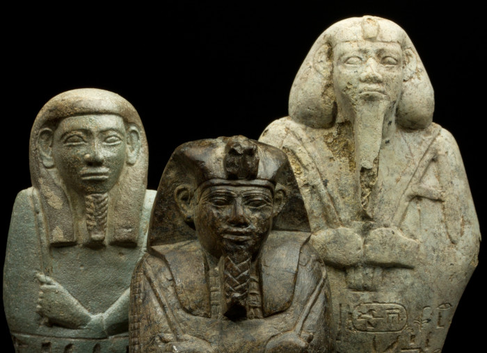
Sudan – heritage of the past
Nothing that happened in the past is irrevocably lost, says an old Arab proverb. Dead cultures and civilizations may be buried in the sands of the desert for centuries until the hand of the archaeologist reveals them anew and brings them back to life. Yet some elusive, ethereal element of the past civilizations can be found in the people who today inhabit the land of ancient treasures.
This is the modern day Sudan– a country that became a successor of a glorious, distant past which allows its inhabitants look to the future with hope.